


TrailView
TrailView
TrailView is the kind of travel app I would consider before heading somewhere with weak coverage, confusing trail junctions, or a real chance of taking the wrong turn. I reviewed it as a free Android app from TrailView, aimed at outdoor navigation and off-road travel rather than ordinary city commuting. Its purpose is easy to understand: help you keep track of trails when a normal road-navigation app is not the right tool.
That focus matters. Google Maps and Apple Maps are excellent for streets, addresses, businesses, and turn-by-turn driving, but they are not designed around every dirt track, back road, or recreational route. TrailView sits in a narrower space. It is more relevant when the journey itself is the destination, and when staying oriented is more important than finding the fastest route between two addresses.
My overall impression is practical rather than flashy. I would not choose it simply because I want another general-purpose map. I would choose it when I am planning an off-road drive, checking a trail area, or trying to avoid losing my bearings away from familiar roads. The app has a modest average rating of 3.4 from around 130 ratings, so I would approach it with sensible expectations rather than treating it as a flawless replacement for every navigation tool.
How TrailView feels in real outdoor use
Speed expectations before leaving the road
The first thing I would do with TrailView is prepare before reaching the trailhead. Outdoor navigation is different from opening a map in town: a route may become difficult to interpret precisely when the signal weakens, the surroundings look repetitive, or several tracks appear to lead in the same direction. That means perceived speed is not only about how quickly a screen opens. It is also about whether I can understand the route without repeatedly waiting, zooming, or correcting my position.
TrailView’s narrow purpose makes the experience easier to judge than a large app packed with unrelated tools. I would use it as a focused reference during a trip, not as a constantly running companion for every part of the day. Before driving, I would inspect the route, identify the main turns, and make sure I understand where the trail begins and where the more confusing sections are likely to be.
Related News

Why WhatsApp Messenger Still Makes Everyday Communication Feel Easy

Jurassic World: The Game Is the Better Dino Tycoon for Strategic Players

Threads in Real Life: Who Should Join, Lurk, or Leave

How SHEIN Turned Shopping Into an Endless Content Feed
How to Make Fortnite Feel Smarter on Mobile

Should You Switch to Microsoft Outlook on Mobile?
A useful habit is to stop and check the map at obvious decision points rather than staring at the phone continuously. That saves battery, reduces distraction, and gives the app fewer moments where it must compete with other active apps. It also makes the navigation process calmer. In an off-road setting, rushing because the map feels unfamiliar can be more dangerous than taking a minute to confirm the direction.
I would also avoid judging the app solely by how quickly it behaves on a strong home connection. The meaningful test is the transition from ordinary coverage to a remote area. If I were preparing for a long outing, I would open TrailView in advance, examine the relevant area, and keep a backup plan in mind. A navigation app can be useful without being the only thing I trust.
What happens during heavier use
The demanding moments are likely to come when I am moving between map views, checking several branches, or repeatedly waking the screen while driving slowly along an unfamiliar route. These actions are more intensive than glancing at a single location once. They also create a practical trade-off: the more often I keep the display active and inspect the map, the more pressure I place on the phone’s battery, regardless of which navigation app I use.
Gallery
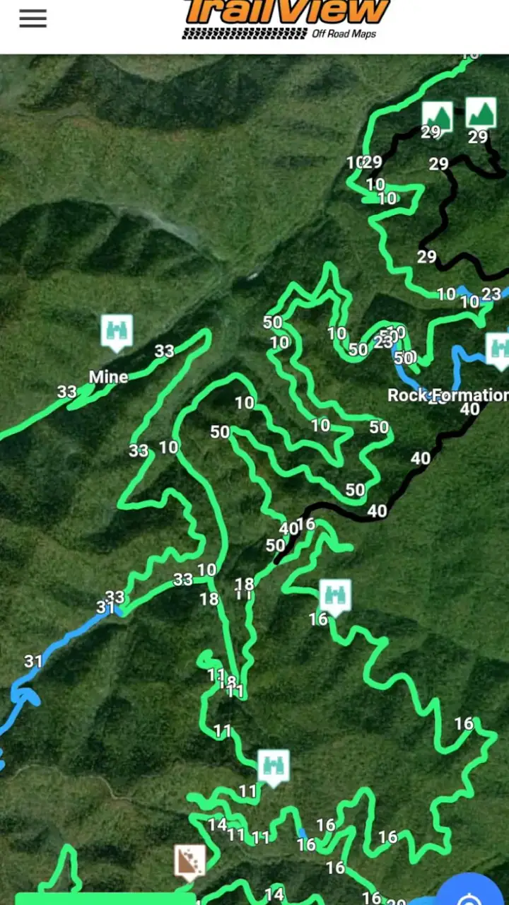
For that reason, I would treat TrailView as part of a small off-road workflow. I would charge the phone beforehand, close apps I do not need, lower the screen brightness to a readable level, and carry a power bank on longer trips. Those steps are not glamorous, but they are more valuable than expecting any mapping app to solve battery limitations by itself.
One non-obvious advantage of this approach is that it separates planning from active navigation. I can use the app intensively for a short preparation session, then rely on occasional checks while travelling. That reduces the chance of turning the phone into a permanent dashboard. It also helps me notice whether the route is genuinely clear before I am already in a difficult section.
In a realistic scenario, imagine leaving a paved road after a weekend drive and reaching a fork where both tracks look plausible. I would pull over safely, open TrailView, compare the branches with the route I had already reviewed, and continue only after I was comfortable with the choice. If the app takes a moment to refresh or the screen is hard to read in sunlight, stopping first is the right response. Outdoor navigation should never encourage hurried phone handling.
Stability and recovery when the trip gets messy
Reliability matters more here than visual polish. A small delay in a shopping app is harmless; uncertainty on an isolated trail can become a serious inconvenience. I would therefore judge TrailView by how confidently I can return to the route after interruptions. That includes putting the phone away for a while, moving through areas with inconsistent reception, or switching briefly to another app.
My recommendation is to build recovery into the trip instead of assuming everything will remain perfect. Before setting off, I would note the trailhead and major junctions in a simple written plan. I would also tell someone where I am going if the route is remote. TrailView can support orientation, but it should not replace basic preparation, local knowledge, or sensible safety decisions.
The recovery workflow is straightforward: stop in a safe place, reopen the app, allow the map to settle, and compare the current position with the route rather than making a quick guess. If I had already studied the route, I would have a much easier time recognizing whether I had merely paused or actually drifted onto the wrong branch. This is one of the strongest reasons to preview the journey instead of treating the app as something I only open after getting lost.
I would be cautious about relying on it as the sole source of truth during a trip where conditions can change. Trails may be blocked, private, muddy, damaged, or unsuitable for a particular vehicle even when a map appears to show a usable line. TrailView can help with orientation, but it cannot make a questionable route safe. That distinction is important for drivers who may interpret a mapped trail as a recommendation.
Device limits and everyday practicality
TrailView supports Android devices running version 7.0 or later, which gives it a fairly broad reach among older phones. That is useful for people who keep a spare handset in a vehicle or use an older device for outdoor trips. At the same time, an older compatible phone may have a smaller display, weaker battery, slower storage, or less comfortable performance than a newer model.
Those hardware differences will shape the experience. A modern phone with a bright screen and a healthy battery is easier to use on a trail than an aging handset that dims quickly or struggles after hours away from a charger. I would not buy a new device specifically for this app, but I would choose the most dependable phone available rather than automatically using the oldest one in a drawer.
Screen size is another practical consideration. A compact phone is convenient to carry, yet detailed trail decisions can be harder when labels and route lines occupy a small display. A larger screen improves scanning, but it is less convenient to mount or protect in a vehicle. My preference would be a phone that I can read quickly without holding it close to my face, with the map checked only while stopped.
TrailView is free to install, which makes it easy to test on the device I already own. It also includes in-app purchases ranging from $0.99 to $29.99 per item. I would pay attention to any purchase screen before committing, especially if I am evaluating it for occasional use. The free entry point lowers the risk of trying it, but the presence of optional purchases means I would not assume every useful part of the experience is included without checking inside the app.
The age rating is Everyone, so the app is not presented as restricted to adults. That does not change the safety responsibilities of an outdoor trip. A young user may be able to operate the app, but route decisions, vehicle access, weather, and remote travel still require adult judgement where appropriate.
Where it fits beside familiar alternatives
I see TrailView as a companion to mainstream navigation rather than an automatic replacement. For the drive from home to a trailhead, I would still prefer a regular road-navigation app because it is built around addresses, traffic, and urban routing. Once the paved route ends, TrailView becomes more relevant because my question changes from “How do I reach this address?” to “Which trail or track should I be following?”
Dedicated outdoor mapping services may be a better choice for people who need extensive planning, specialized activity layers, detailed route recording, or a mature ecosystem around a particular sport. If I were organizing repeated expeditions, comparing many trails, or needing advanced planning tools, I would investigate those alternatives carefully. TrailView makes more sense for someone who wants a focused off-road aid without immediately committing to a larger outdoor-navigation system.
Paper maps still have a role, especially as a backup. They do not run out of battery, freeze, or become difficult to read because of glare in the same way a phone can. Their weakness is that they do not update my position automatically. I would combine a basic printed plan with TrailView on a serious trip, not choose one and pretend the other has no value.
The key trade-off is simplicity versus depth. A focused app can be less intimidating than a feature-heavy platform, but it may not satisfy users who want every possible planning and tracking function in one place. I would recommend TrailView to a casual off-road driver, a weekend explorer, or someone testing whether trail navigation is useful to them. I would be more hesitant to recommend it as the only navigation system for professional fieldwork or demanding multi-day travel.
Version, support expectations, and who should try it
The current version is 1.6.0, while the app has been available since April 9, 2019. That history suggests a product with time in the market, but I would still evaluate it on present-day usefulness rather than assuming age guarantees maturity. The developer is TrailView, and the app has passed the fifty-thousand-install mark, so it is not an unknown experiment with no public adoption at all.
I would try it first on a familiar route. That is the safest way to learn how quickly the map responds on my phone, how comfortable the controls feel, and how easy it is to recover after leaving the app. A short test also lets me decide whether the available information matches the kind of trails I use. Testing near home is far better than discovering a limitation deep in an unfamiliar area.
Someone who mainly travels through cities, depends on live traffic, or wants effortless address-to-address directions should probably stay with a conventional navigation app. TrailView’s appeal is specific. It is for the moment when ordinary road guidance stops being enough and I need a clearer relationship with trails and off-road routes.
My performance verdict after weighing the trade-offs
TrailView earns its place as a focused tool for off-road orientation, especially because it is free to start and supports older Android devices from version 7.0 onward. I like the idea of preparing a route with it, checking uncertain junctions carefully, and using it alongside a normal road map and a simple backup plan. That workflow respects both the app’s strengths and the realities of outdoor travel.
I would not describe it as a universal navigation solution. Battery condition, screen quality, reception, route conditions, and the depth of information I need will all affect the result. The optional purchases also deserve a careful look before I spend money, and the modest average rating of 3.4 means I would personally test it rather than relying on reputation alone.
My honest recommendation is to treat TrailView as a practical off-road helper, not a substitute for preparation. Try it on a low-risk outing, learn how it behaves on your phone, and keep another way to understand the route. If your trips regularly involve trails where ordinary map apps feel out of place, it is worth exploring. If you need advanced expedition planning or dependable professional-grade navigation, a more specialized alternative may suit you better.
In the end, the app’s value depends on how narrowly your travel needs match its purpose. For the right user, that narrow focus is a benefit: fewer distractions and a clear reason to open it. For everyone else, a standard navigation app may be simpler. I would keep TrailView in my outdoor toolkit for trail-focused journeys, while making sure the journey never depends on a single screen, a single signal, or a single assumption.
FAQs for TrailView
What is TrailView and what can I use it for?
TrailView is designed to help users explore, view, and understand outdoor trails through a convenient mobile interface. Depending on the available map data, you can use it to browse routes, check trail details, plan an outing, and follow your progress while outdoors. It is particularly useful for hikers, walkers, cyclists, and anyone who wants a clearer overview of nearby paths before starting a trip.
Does TrailView work without an internet connection?
TrailView’s offline usefulness depends on the specific version, map coverage, and whether the required trail information can be downloaded in advance. Before heading into an area with weak reception, open the relevant maps or routes and check whether offline access is available. You should not assume that every feature, map update, search tool, or location service will work without an active internet connection.
Is TrailView accurate enough for hiking and outdoor navigation?
TrailView can be a helpful planning and navigation companion, but it should not be treated as your only safety tool. Trail information may change because of closures, weather, construction, private land, or outdated map data. GPS accuracy can also vary in forests, valleys, and remote areas. Always compare the app with official signs, local guidance, a physical map, and appropriate outdoor safety equipment.
What permissions does TrailView require?
TrailView may request access to your location so it can display your position, record movement, or provide route guidance. It may also need internet access to load maps, search for places, synchronize information, or download updates. Review each permission request carefully and enable only what you are comfortable sharing. Location features may be limited if permission is denied, especially while the app is running in the background.
Is TrailView free to download, and are there in-app purchases?
TrailView’s download and core features may be free, but availability of premium maps, advanced route tools, offline content, advertising removal, or other extras can vary by platform and version. Check the Google Play Store or Apple App Store listing before installing, paying particular attention to subscriptions and renewal terms. If you plan to use TrailView regularly, confirm exactly which features are included at no cost.
Pros
- Clear trail maps make route planning quick and convenient.
- Offline access helps when hiking beyond reliable mobile coverage.
- Useful elevation details help prepare for steep climbs and descents.
- Location tracking makes it easier to monitor progress on longer hikes.
- Supports safer exploration by showing nearby trails and route options.
Cons
- Map accuracy may vary depending on local trail data and updates.
- GPS tracking can drain your phone battery during extended hikes.
- Some advanced features may require a subscription or in-app purchase.
- Dense trail areas can make map selection confusing on a small screen.
- Weather and terrain conditions may not be reflected in the listed routes.


